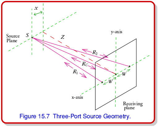
Figure 15.7 shows the geometry we can use to analyse the 3-port situation when it views a source at a distance,  , from the receiver plane that is offset by an amount,
  , from the normal direction to the central port.
From simple trigonometry we can say that the three lengths from the source to the ports will be
where  is the port spacing. Provided that the range is far larger than either
  or
or  the path lengths from the source to the side ports will differ from that to the central port by amounts which will cause relative received phase differences
at a signal wavelength,  . Hence if we measure the signal phases received at the side ports relative to that received at the center port we can rearrange the above to say that we will be able to computer the range and bearing offset,
  , using these phases, from the expressions
Spatial interferometry has a number of advantages over radar. The most obvious ones stem from the fact that the measuring system doesn't have to emit any power. It can therefore avoid the safety/environmental problems associated with high power radar. It also means a relatively low operating cost since no money is being ‘burned’ to radiate megawatts into space. Since it uses power radiated by the source/target the received signal only falls with the square of the range not it's fourth power. Given sensitive detectors it can detect the thermal radiation emitted/reflected by the target. This means the detection system need not advertise to a target that its position is being measured.
Just as with the 2-port system, a wideband interferometer provides us with a measurement of the source's spectrum. This is an important point as it means we can use this spectral information to help identify the nature of the source. Significantly, the system can also provide an absorbtion spectrum produced by a cool/semi-transluscent object place ‘in front’ of a more distant, brighter source. This means we can use spatial interferometry in environmental applications to ‘map’ pollutants and other chemicals which produce 3-dimensional patterns of inhomogeneity in the field of view. Using wideband mm-wave to terahertz (THz) systems we can simultaneously map many hundreds of chemicals. This means we can do things like identify which factories are producing what pollutants, and their concentrations/temperatures.
Although Lidar (‘radar with light’) is useful for pollution mapping, its narrowband nature tends to restrict its use to one chemical at a time. It also requires a high power laser, and is subject to all the problems/limitations of conventional radar. Hence spatial interferometry is the better choice for many applications. THz systems can provide spatial accuracies of the order of metres in range and millimetres in offset at ranges of the order of 10 km. Hence they can compete with radar in terms of mapping resolution/accuracy. Their main drawback has been that, until the last decade, it was difficult to build the required systems. This practical problem has now, however, largely disappeared with the development of high performance quasi-optical circuits.
Summary.
You should now understand how a Radar system is able to measure the range to a reflective target. That the radar uses a circulator to simultaneously connect a transmitter and receiver to a common antenna. That the main limitations of radar are range cell ambiguity, caused by the pulse repeat rate, and the tendency for the reflected level returned to the radar to fall as the fourth power of the range, as indicated by the radar equation. That this radar equation does not apply to ground/cloud radar and in other situations where the target fills the field of view. That CWFM radars have power level advantages over pulsed systems. That Doppler radar lets us measure the velocity of a target in the line of sight. You should now also see how spatial interferometry can measure the range of a source (or absorbing item in front of an emitting background). That a spatial interferometer can provide both positional and spectral information and does not suffer from the same problems as conventional radar. That the spatial interferometer works by detecting phase/time changes caused by the curvature of the wavefront arriving from a source at a finite range.


 Content and pages maintained by: Jim Lesurf (jcgl@st-and.ac.uk)
using
TechWriter Pro and HTMLEdit on a StrongARM powered RISCOS machine.
University of St. Andrews, St Andrews, Fife KY16 9SS, Scotland.